

Breckenridge and Stephens County prepare for winter storm
By Carla McKeown/Breckenridge Texan
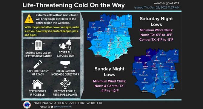
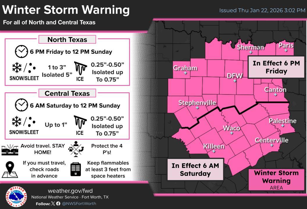
The first big winter storm of the season, especially for this area, is forecast for this weekend, prompting preparations from people in a wide swath of the country, from the Southern Plains to New England. Breckenridge and Stephens County are under a Winter Storm Warning and an Extreme Cold Watch with the low temperature predicted to get as low as 2 degrees overnight Sunday-Monday.
(Courtesy of the National Weather Service)
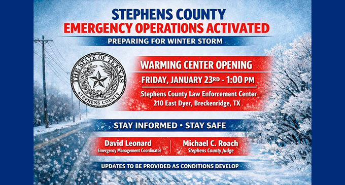
Stephens County will open a warming center at 1 p.m. Friday, Jan. 23, at the Stephens County Law Enforcement Center, 210 E. Dyer St.
The warming center will be available to residents who may need a safe, warm location during the winter weather conditions.
Stephens County is also working in close coordination with the City of Breckenridge, the Texas Department of Transportation, Stephens Memorial Hospital, Breckenridge Independent School District, and first responders across the county to monitor conditions, prepare response assets, and provide timely updates to the public.
Residents are encouraged to remain weather-aware, take appropriate precautions, and follow official county communications and local media outlets for updates as the situation develops. Additional information and updates will be provided as conditions change.
The National Weather Service reminds everyone that cold temperatures will become life threatening to people and animals outside without adequate warmth or shelter, and damage to plumbing is likely if pipes are not properly drained or insulated.
The NWS recommends that everyone have an emergency kit and enough supplies ready in case of power outages. Make sure you have on hand at least a few days worth of food, water, medications and other basic necessities for yourself, your family and your pets to sufficiently ride out the storm.
Other tips include:
- Make frequent checks on vulnerable family, friends, and neighbors.
- Ensure portable heaters are used correctly.
- Keep pets safe and warm. Make sure outdoor animals have a warm, dry shelter, food, and unfrozen water.
- Prepare for power outages — have battery-operated flashlights available and keep portable phone chargers charged up. Make sure your fireplace/chimney are ready to use, and make sure you know how to safely use non-electric portable heaters. Do not use generators or grills inside.
- Protect pipes — insulate water pipes, if possible; leave sink cabinets open to provide heat to the pipes; disconnect hoses and turn off water sprinklers.
- Have bottled water on hand, in case your water pipes freeze.
- Avoid going outside during sub-freezing temperatures, and if it’s necessary, dress appropriately and limit your time outside.
- If you must travel, drive with extreme caution. Take a winter storm kit along with you, including such items as tire chains, booster cables, flashlight, shovel, blankets and extra clothing. Also take water, a first aid kit, and anything else that would help you survive in case you become stranded.
Also in preparation for the winter storm, the City of Breckenridge has announced the following altered trash pick-up schedule:
- Friday’s (Jan. 23) trash pick-up will run one hour early. Put trash bins out on Thursday evening.
- There will be no trash pick-up on Monday, Jan. 26.
- Trash will pick-up resume on Tuesday, Jan. 27, running one day behind (Monday’s route picked up Tuesday, Tuesday’s route picked up Wednesday, etc., through Saturday).
According to the National Weather Service, tonight should be mostly cloudy, with a low around 44 degrees. On Friday, the high will likely peak at just after midnight (late Thursday night into early Friday morning) with the temperatures then dropping steadily throughout the day. Rain showers can be expected all day with precipitation amounts between a quarter- and half-inch possible.
On Friday night, rain showers and freezing rain, turning to mostly freezing rain up until 3 a.m., and freezing rain, possibly mixed with sleet after 3 a.m. The overnight low from Friday night to Saturday morning is expected to be around 20 degrees. New ice accumulation of 0.1 to 0.3 of an inch is possible. New sleet accumulation of less than a half inch is possible.
On Saturday, local residents can expect freezing rain and sleet with temperature falling to around 21 degrees by 5 p.m. and north winds from 10 to 15 mph, with gusts as high as 20 mph. The chance of precipitation (wintery mix) on Saturday is 100%. Saturday night, snow showers and sleet, possibly mixed with freezing rain, are expected before 3 a.m., then snow showers and sleet. Saturday’s overnight low is predicted to be around 10 degrees with north winds from 10 to 15 mph, with gusts as high as 20 mph.
On Sunday, there is a chance of snow showers and sleet before noon. It should be partly sunny and cold, with a high near 23 and a north-northwest wind from 10 to 15 mph, with gusts as high as 20 mph. The chance of precipitation on Sunday is 40%. Sunday night should be mostly clear, with a low around 2 degrees and a north-northwest wind from 5 to 10 mph becoming light west-northwest.
Monday is expected to be sunny, with a high near 37, dropping back down to 18 degrees overnight. The sunny weather should continue on Tuesday with a high near 48 degrees.
Winter Storm Warning


